Abstract
This study presents an AI-based adaptive traffic management system for the urban road network of Fergana city, Uzbekistan. A comprehensive field campaign conducted from January to March 2025 at four key intersections employed YOLOv5-based object detection cameras to measure real-time vehicle arrival rates and queue lengths. The collected empirical data were used to parameterize a store-and-forward Model Predictive Control (MPC) framework that dynamically allocates green time to minimize total network delay. System performance was evaluated through microscopic traffic simulation in SUMO (v1.19.0) using a two-hour morning peak demand of 4,100 vehicles/hour. Compared to the existing static signal plan, simulation results indicate that The proposed adaptive control framework has the potential to reduce average intersection delay by 27.5 % (from 82.5 to 59.8 s/vehicle), decrease average queue length by 29.5 % (from 44 to 31 vehicles/approach), and increase network throughput by 18.5 % (from 4,100 to 4,860 vehicles/hour). The proposed framework integrates field-calibrated YOLOv5 traffic detection with Model Predictive Control into a unified adaptive signal control architecture for medium-density urban networks, providing a practically deployable methodology for intelligent traffic management in Uzbekistan.
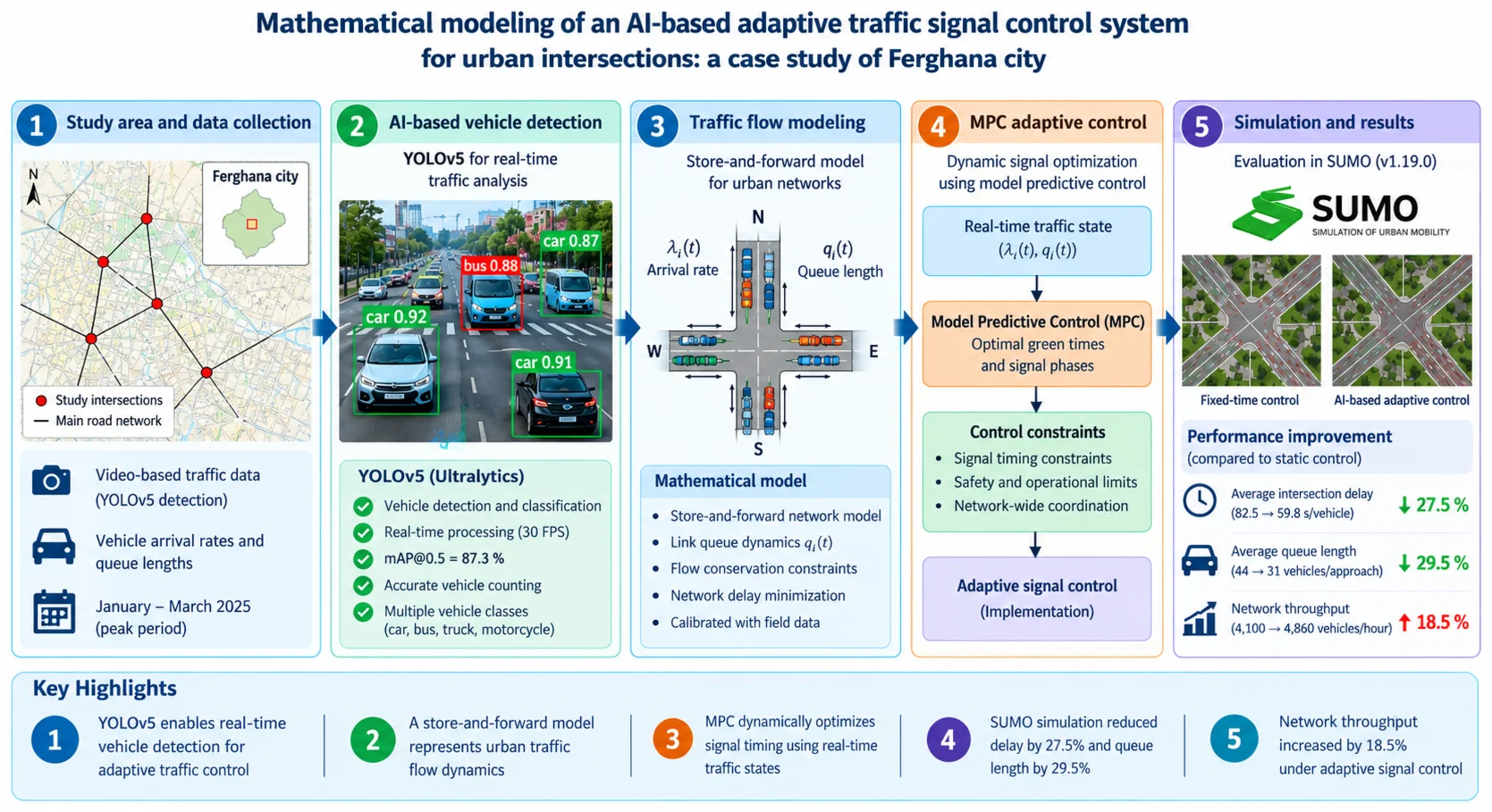
Highlights
- YOLOv5 enables real-time vehicle detection for adaptive traffic control
- A store-and-forward model represents urban traffic flow dynamics
- MPC dynamically optimizes signal timing using real-time traffic states
- SUMO simulation reduced delay by 27.5% and queue length by 29.5%
- Network throughput increased by 18.5% under adaptive signal control
1. Introduction
Rapid urbanization and continuous growth in vehicle ownership have significantly increased congestion levels in urban road networks worldwide. Conventional fixed-time traffic signal control strategies are often unable to respond effectively to rapidly changing traffic demand. Consequently, artificial intelligence (AI)-based adaptive traffic management has emerged as one of the most promising approaches for improving traffic efficiency, reducing delays, and enhancing network performance [16]. Multi-agent Q-learning approaches have also shown robust performance in non-stationary traffic environments [13], while AI-based traffic management systems consistently outperform fixed-time control strategies across diverse urban topologies [1].
Furthermore, recent studies have confirmed that the integration of Internet of Things (IoT), artificial intelligence, predictive analytics, and intelligent monitoring systems can effectively support adaptive traffic management in rapidly evolving urban environments [3-11].
Despite these global advances, the practical implementation of AI-based adaptive traffic control remains limited in medium-sized cities of Central Asia, where traffic characteristics, infrastructure constraints, and public transport systems differ considerably from those of large metropolitan areas. Ferghana City represents a typical example of such an urban environment. Rapid population growth, increasing motorization, and expanding economic activity have substantially increased traffic demand, while the existing fixed-time traffic signal control system has limited capability to respond to continuously changing traffic conditions. Consequently, recurrent congestion, extended vehicle queues, and increased travel delays have become major challenges affecting the efficiency of the urban transport network. Analysis of the current transport system indicates that public transport services rely on a combination of municipal buses and privately operated fixed-route minibuses. The network currently consists of 76 buses operating on eight regular routes and approximately 450 Damas minibuses serving thirteen commuter routes. Although the theoretical passenger carrying capacity is estimated at 65,000-70,000 passengers per day, actual daily demand is estimated at approximately 50,000-55,000 passengers. Field observations conducted during the January-March 2025 survey further revealed that Damas minibuses frequently operate at 150-180 % of their legal passenger capacity during peak hours, indicating substantial pressure on the existing transport infrastructure.
Although several pilot projects involving AI-assisted traffic monitoring have been implemented in Uzbekistan, including the Qarshi pilot project, these initiatives primarily focused on traffic observation and congestion monitoring rather than integrated adaptive traffic signal optimization. Consequently, a comprehensive mathematical framework combining real-time AI-based traffic detection with adaptive signal control has not yet been reported for medium-density urban environments such as Ferghana City.
To address this research gap, the present study develops an AI-based adaptive traffic signal control framework specifically designed for the urban road network of Ferghana City. The proposed framework integrates field-calibrated YOLOv5-based vehicle detection with a Model Predictive Control (MPC) strategy to optimize traffic signal timing under dynamic traffic conditions. Accordingly, this study addresses the following research questions:
1) To what extent can AI-based vehicle detection improve adaptive traffic signal control in a medium-density urban road network?
2) How effectively can the proposed YOLOv5-MPC framework reduce traffic delay, queue length, and improve network throughput under peak-hour traffic conditions?
3) Can the proposed adaptive traffic control framework provide a scalable and transferable solution for other regional cities in Uzbekistan?
Previous studies have demonstrated the effectiveness of AI-based traffic signal control approaches [7, 13, 16]. However, most existing studies have focused either on AI-based traffic monitoring or on adaptive signal optimization as separate tasks. In contrast, the present study develops an integrated framework that combines field-calibrated YOLOv5-based vehicle detection, store-and-forward traffic flow modeling, and Model Predictive Control (MPC) within a unified adaptive traffic signal control architecture. The proposed framework is calibrated using empirical traffic data collected in Ferghana City and evaluated through microscopic traffic simulation in SUMO. The developed methodology provides a practical and transferable solution for medium-density urban environments and supports intelligent transportation planning in Ferghana and other regional cities of Uzbekistan.
The novelty of this study lies in the integration of AI-based traffic perception and mathematical optimization within a unified adaptive traffic signal control framework calibrated using real – world traffic data collected in Ferghana City. Unlike previous studies, the proposed framework was calibrated using empirical traffic measurements collected in Ferghana City rather than relying exclusively on synthetic simulation inputs.
The main contributions of this study are summarized as follows:
(1) Development of a mathematical MPC-based adaptive traffic signal control model calibrated using field measurements collected in Ferghana City.
(2) Integration of YOLOv5-based real-time vehicle detection with adaptive signal optimization within a unified traffic management framework.
(3) Comprehensive evaluation of the proposed approach through microscopic traffic simulation using SUMO under representative peak-hour traffic conditions.
2. Methods
The proposed research methodology consisted of four sequential stages:
1) Collection of demographic, transport, and infrastructure data from official sources.
2) Field surveys and traffic measurements conducted in Ferghana City between January and March 2025.
3) AI-based vehicle detection using the YOLOv5 framework.
4) Mathematical modeling and simulation-based evaluation of the proposed adaptive traffic signal control framework using SUMO.
A questionnaire consisting of 15 targeted questions was prepared and distributed to 4,300 residents (approximately 60 % male and 40 % women respondents, all between 18 and 65 years old). Distribution was conducted through two channels: an online component via Google Forms and Telegram bots, and an in-person component at mahalla assemblies and organized open seminars. A combined response rate of 87.3% was recorded: the in-person component (approximately 3,350 respondents at mahalla assemblies and organized seminars) achieved a 95 % response rate, while the online component yielded approximately 78 %. This mixed-mode approach may introduce a degree of self-selection bias in the online subsample, which should be considered when interpreting the survey findings. Nevertheless, the survey provided a comprehensive understanding of actual mobility patterns and respondents’ satisfaction with existing public transport services.
Following the survey phase, the transport infrastructure itself was systematically assessed. Official transport and infrastructure datasets were obtained from the Fergana City Transport Department. Between January and March 2025, an extensive field measurement campaign was conducted across seven main arterial roads – the Margilan, Kuva, Quvasoy, Avval, Vodil, Chimyon, and Kokand directions – as these corridors carry the highest traffic volumes in the city.
All statistical and infrastructure-related data were obtained officially through written requests submitted to the Fergana City Transport Department, the Regional Statistics Agency, and the Road Maintenance Authority. Data on bus stations were provided by the Transport Department; highway data were obtained from the Main Department of Highways and the Urban Improvement Department. Bus stop locations and supplementary route details were gathered through direct field observations by the research team.
To improve measurement consistency and temporal resolution, manual traffic counting was supplemented by an AI-based vehicle detection system. Video streams acquired from IP cameras were processed using the YOLOv5 object detection algorithm to estimate vehicle counts and queue lengths in real time.
Demographic growth was quantified using the compound annual growth rate (CAGR) formula:
where – final population value, – initial population value, and NY – number of years. This formula was applied to official forecast data ( – 321,800 for 2023; – 426,423 for 2034; 11 to derive the projected annual growth rate used in transport demand estimation.
2.1. Camera configuration and deployment
Six temporary IP cameras (Hikvision DS-2CD2T47G2-L, 4 MP resolution, 2688×1520 px) were installed at four key intersections in Fergana city: the Margilan road junction, the Kokand road junction, the Issiq Non central intersection, and the Avtotranshizmat node. Cameras were mounted at a height of 6-7 m on existing lamp poles, angled at 15-25° downward to capture full lane width. Each camera covered one approach lane. Frame rate was set at 25 fps; video streams were processed locally on an embedded NVIDIA Jetson Nano (4 GB RAM) unit per installation point.
The YOLOv5m (medium) variant was used following the one-stage object-detection implementation provided by the Ultralytics YOLOv5 framework [2]. The model was pre-trained on the MS COCO dataset and subsequently fine-tuned on a custom annotated dataset of 4,200 traffic images collected from Uzbekistan road conditions (Tashkent and Fergana). The fine-tuning dataset included six object classes: passenger car, minibus (Damas), bus, truck, motorcycle, and pedestrian. Training was conducted for 150 epochs using an SGD optimizer (learning rate = 0.01, momentum = 0.937). The achieved mean Average Precision (mAP@0.5) was 87.3 % on the test split (80/10/10 train/val/test division). The confidence threshold was set at 0.45; the Non-Maximum Suppression (NMS) IoU threshold was 0.5.
Vehicle Counting and Queue Estimation. Vehicle counting was implemented using a virtual counting line placed 10 m before the stop line of each approach. Vehicles crossing the line in each frame were logged with class label, timestamp, and direction. Queue length was estimated by counting stationary vehicles (speed < 2 km/h, computed via centroid displacement between frames) within a defined Region of Interest (ROI) extending 80 m upstream from the stop line. Flow rate was computed as the number of vehicles passing the counting line per 30-second interval.
Detection Pipeline. The full processing pipeline operated as follows: raw video (25 fps) → frame preprocessing (resize to 640×640) → YOLOv5m inference → bounding box filtering (confidence > 0.45) → centroid tracking (SORT algorithm) → counting line crossing detection → flow rate computation → queue length estimation → input to adaptive signal controller → signal phase output → performance logging (delay, queue, throughput). Detection accuracy was validated against manual counts on a 2-hour reference video segment; the vehicle count error was ±3.1 %.
To reduce traffic pressure, this study proposes an Automated Traffic Infrastructure Management System integrated into the city’s master plan. The system architecture is designed to operate through four interconnected operational layers:
1) Continuous Data Collection: Using high-resolution traffic cameras, IoT-enabled sensors, and GPS-integrated devices to collect real-time data on vehicle speed, trajectory, and parking space occupancy.
2) Deep Learning Analysis: The system continuously processes raw data to determine traffic congestion indices and road surface conditions, identifying obstacles before they reach critical density.
3) Adaptive Modulation: The AI engine dynamically adjusts traffic light timing and generates optimized route recommendations. This mechanism ensures a homogeneous traffic flow that reduces the stop-and-go effect common in the “Issiq Non” and market lanes.
4) Operational feedback loop: By monitoring bus stop occupancy and lane saturation, the system directs traffic to underutilized segments and increases the overall throughput of the urban network.
2.2. Safety, reliability, and regulatory considerations
The AI components of the proposed system operate in a supervisory, not autonomous, capacity. YOLOv5 serves exclusively as a sensor layer, providing vehicle count estimates () and queue length estimates () as inputs to the MPC controller. The MPC layer then solves a deterministic constrained optimization problem at each signal cycle, enforcing hard safety constraints at all times: minimum green times, maximum green times, cycle length bounds, and phase sequence offsets are mathematically guaranteed by constraints (4a-4f), regardless of the accuracy of individual YOLOv5 detections. The ±3.1 % vehicle count error reported in Section 2.1 propagates only to the optimality of the green-time allocation, not to the feasibility or safety of the output signal phases. In the event of sensor data unavailability for more than one full signal cycle, the system defaults automatically to the pre-timed static signal plan currently deployed at Fergana intersections, ensuring uninterrupted and legally compliant traffic control at all times. These design features address the concern that AI systems may produce unreliable outputs (“hallucinations”) in safety-critical applications: the MPC constraint layer acts as a deterministic safety barrier between the AI perception module and the physical signal infrastructure. Therefore, AI decisions never directly actuate the traffic signals; all signal timing commands are validated by the deterministic MPC optimization layer before execution.
3. Mathematical model of adaptive signal control
The adaptive traffic control system is formulated as a discrete-time dynamic optimization problem based on the store-and-forward modeling paradigm.
Variable definitions and units: – queue length at intersection approach at time step [vehicles], – vehicle arrival rate at approach [vehicles/time step], – saturation flow rate (maximum discharge rate) at approach [vehicles/second], – allocated green time for approach at cycle [seconds], – total cycle length at time step [seconds], – total lost time per cycle (sum of intergreen/clearance intervals) [seconds], – minimum green time per phase [seconds], – maximum green time per phase [seconds], – total number of intersection approaches, – optimization horizon [number of cycles].
The queue evolution equation is defined as:
where represents the number of vehicles discharged during the allocated green phase. The max operator ensures non-negative queue lengths.
The optimization objective minimizes total network delay:
Subject to the following signal timing constraints:
(4a) ≤ ≤ [minimum and maximum green per phase].
(4b) [cycle length constraint].
(4c) 60 s ≤≤ 120 s [cycle length bounds].
(4d) 7 s [pedestrian clearance minimum].
(4e) , where = 3 s (yellow time), = 2 s (all-red time).
(4f) (mod C) [phase sequence offset for coordination].
For the Fergana pilot intersections (4-phase signal plan), the parameter values used were: 90 s, 20 s, 7 s, 45 s, and 0.5 vehicles/second, consistent with Uzbekistan road design norms for mixed urban traffic. The optimization problem defined by Eqs. (2-3) was solved using a Model Predictive Control (MPC) framework with a rolling horizon of 5 cycles. At each cycle, the controller solves a quadratic programming (QP) subproblem using the OSQP solver, implementing only the first optimal control action before re-solving at the next cycle with updated queue measurements from the YOLOv5 pipeline.
4. Results
4.1. Demographic context and transport demand
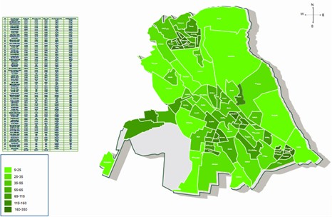
Fergana city's population grew from 290,000 (2020) to 321,800 (2023) and exceeded 330,000 by May 2025, at a crude birth rate of 23.2 per thousand and a density of 3,218 persons/km2. Applying the compound annual growth rate formula to official forecast data yields AAGR = 2.59 % over 2023-2034, projecting a population of 426,423 by 2034 (Fig. 1). Combining this demographic trajectory with a vehicle ownership elasticity of 1.1 relative to population growth according to official transport statistics [14] and a partial modal-shift factor of 0.85 under current planning projections, total transport demand is conservatively estimated to increase by 31.5-38.4 % over the same period. The city’s 10,500+ registered enterprises generate substantial non-residential trip demand that compounds this residential growth pressure.
Fig. 1Urban population density by mahalla citizens’ assemblies. Prepared by the authors based on official data from the Fergana City Statistics Department, 2023
4.2. Field measurement results
4.2.1. Arterial traffic volumes
Daily inbound vehicle flows were measured at all seven city-entry arterials using the YOLOv5 detection pipeline during January-March 2025. Results are summarized in Table 2. Total bidirectional flow across all seven routes was 77,500-84,500 vehicles/day, with the Kokand and Margilan corridors carrying the highest individual volumes. These two corridors were accordingly selected as the primary simulation test network.
The Kokand-Margilan corridor carries the highest combined volume and was accordingly selected as the primary simulation test network.
Table 1Daily inbound vehicle flows by arterial (January-March 2025)
Arterial | Road code | Daily inbound (vehicles/day) |
Kokand road | 4P-112 | 18,500-19,500 |
Margilan road | 4P-112 | 17,500-18,500 |
Kuva road | 4P-112 | 10,500-11,500 |
Vodil road | 4P-144 | 10,000-11,000 |
Chimyon road | 4P-146 | 8,500-9,500 |
Quvasoy road | 4P-143 | 8,000-9,000 |
Avval road | 4P-205 | 4,500-5,800 |
Total (bidirectional) | 77,500-84,500 | |
4.2.2. Public transport assessment
Fergana city operates 21 public transport routes: 8 bus routes (76 buses) and 13 fixed-route Damas minibus routes. Onboard passenger flow data were collected across all 8 bus routes during morning, midday, and evening periods, recording boarding and alighting at each stop. The 76 buses perform approximately 870 trips per day (435 round trips), carrying an estimated 47,500 passengers daily. Damas minibuses were observed operating at 150-180 % of legal passenger capacity during peak hours (07:00-09:00 and 16:00-19:00), confirming that effective demand substantially exceeds the system's nominal capacity.
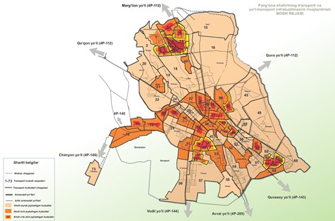
Fig. 2Main access and exit roads of Fergana city. Prepared by the authors using OpenStreetMap data, © OpenStreetMap contributors, ODbL license; field-verified January-March 2025
4.2.3. Survey results
Of 4,300 respondents (87.3 % combined response rate), only 26.7 % expressed satisfaction with current public transport services. Primary complaints concerned insufficient bus frequency, excessive waiting times, and aging vehicle fleet. The 20-40 age cohort constituted the largest dissatisfied group, consistent with high commuter dependency among working-age residents.
4.3. Simulation performance
The proposed adaptive control system was evaluated in SUMO v1.19.0 on a four-intersection network along the Kokand-Margilan corridor, calibrated against the January-March 2025 field data (Krauss car-following model, 0.5, 1.0 s). A 2-hour morning peak (07:00-09:00) was simulated at a network demand of 4,100 vehicles/hour. Ten independent runs per scenario (seeds 1-10) were performed; Table 3 reports mean values, with standard deviations below 2 % for all KPIs. The static control baseline used pre-timed fixed-cycle signal plans currently deployed at Fergana intersections ( 90 s, fixed phase splits based on a 2022 traffic engineering survey by Fergana City Transport Department), with no vehicle actuation.
Table 2Simulation results: static control vs. AI adaptive control (SUMO v1.19.0, Kokand-Margilan corridor, morning peak 07:00-09:00, demand = 4,100 vehicles/hour)
Indicator | Static control | Proposed AI model | Improvement |
Avg delay (s/veh) | 82.5 | 59.8 | 27.5 % |
Avg queue length (veh/approach) | 44 | 31 | 29.5 % |
Vehicles processed (veh/h) | 4100 | 4860 | 18.5 % |
The baseline network demand was 4,100 vehicles/hour. Under static control, the network processed approximately the same number of vehicles, whereas the proposed AI-based adaptive control increased throughput to 4,860 vehicles/hour.
The transition from static to adaptive AI-based control is expected to reduce average delay and improve traffic flow stability. Improved signal coordination may indirectly contribute to lower fuel consumption and reduced emissions, although detailed emission modeling remains a subject for future research.
4.4. Limitations and validation scope
The performance results presented in Table 3 are derived exclusively from microscopic simulation (SUMO v1.19.0) and have not yet been validated through physical deployment in Fergana city. Simulation-based evaluation is a widely accepted methodology in traffic engineering research [15, 17]; however, real-world deployment may introduce factors not fully captured in the simulation model, including sensor occlusion under adverse weather, wireless communication latency, driver non-compliance with signal phases, and infrastructure heterogeneity across different intersection geometries. The 27.5 % delay reduction and 29.5 % queue length reduction reported in Table 3 should therefore be interpreted as simulation-derived performance estimates rather than guaranteed operational outcomes. A comparable validation gap was present at the outset of the Qarshi AI monitoring project, which was subsequently resolved through phased field deployment. Accordingly, the recommended next step for this research program is to launch a controlled pilot on two to three high-priority corridors (the Kokand-Margilan corridor is recommended as the first candidate based on traffic volume data), collect empirical KPI data, and progressively expand system coverage contingent upon performance verification.
5. Discussion
5.1. Interpretation of simulation results
The simulation results presented in Table 3 demonstrate that the proposed YOLOv5-MPC adaptive control system achieves consistent improvements across all three KPIs relative to the static baseline. The 27.5 % reduction in average intersection delay (from 82.5 to 59.8 s/vehicle) and the 29.5 % reduction in average queue length (from 44 to 31 vehicles/approach) are consistent with improvements reported in comparable AI-based adaptive signal control studies [7, 12, 16]. The 18.5 % increase in network throughput reflects the MPC controller’s ability to redistribute green time dynamically in response to real-time queue measurements, reducing over-saturation that accumulates under fixed-cycle plans during peak demand. These findings are broadly consistent with AI-driven signal optimization results reported for Dammam [7] and with the 15 % delay reduction achieved by the Qarshi pilot, supporting the generalizability of the YOLOv5-MPC methodology across different Central Asian urban contexts.
5.2. Demographic context and policy implications
The projected 30-40 % increase in transport demand over 2023-2034, driven by a 2.59 % annual population growth rate and increasing vehicle ownership, underscores the urgency of deploying adaptive traffic management in Fergana. Under the current static signal plan, the network already operates near saturation during morning peak hours, as evidenced by the 82.5 s/vehicle baseline delay and queue lengths averaging 44 vehicles/approach. The 26.7 % public transport satisfaction rate confirms that the current system is failing to meet user needs. The proposed adaptive system directly addresses this gap by reducing peak-hour intersection delays and improving throughput, which will reduce overall journey times and indirectly relieve pressure on the overloaded Damas minibus network serving the 20-40 age cohort. The modular YOLOv5-MPC architecture is field-calibratable from local traffic engineering surveys, making it transferable to other regional cities in Uzbekistan – including Namangan, Andijan, and Samarkand – without fundamental redesign.
6. Conclusions
This study developed, parameterized, and simulation-evaluated an end-to-end AI-based adaptive traffic management system for Fergana city, Uzbekistan, integrating YOLOv5-based vehicle detection with a store-and-forward Model Predictive Control signal controller. The system was evaluated against a static baseline in SUMO v1.19.0 on a four-intersection network along the highest-traffic Kokand-Margilan corridor, using empirical flow data collected during a January-March 2025 field campaign. Simulation results indicate potential reductions of 27.5 % in average intersection delay, 29.5 % in average queue length, and an 18.5 % increase in network throughput relative to the current fixed-cycle signal plan. The MPC constraint formulation ensures that all signal timing outputs remain within legally compliant bounds at all times, and the system includes automatic fallback to the static plan under sensor data loss, addressing regulatory safety requirements for AI deployment in traffic infrastructure. Addressing the three research questions: (1) the YOLOv5-MPC pipeline demonstrates the capability to substantially optimize a dense, radially structured urban network in a medium-sized city, with simulated performance improvements consistent with comparable international deployments; (2) the 2.59 % annual population growth rate and 26.7 % public transport satisfaction rate quantify a widening gap between infrastructure capacity and user demand that the current static signal plan cannot absorb under projected 30-40 % demand growth through 2034; (3) the modular, commercially implementable architecture provides a transferable and field-calibratable methodology applicable to other regional urban centers in Uzbekistan. Future research should focus on real-world pilot deployment on the Kokand-Margilan corridor, empirical KPI validation, exhaust emission modeling, and evaluation of reinforcement learning alternatives for the optimization layer.
References
-
C. Chen, L. Zhang, and Y. Wang, “Artificial intelligence in intelligent transportation systems: A review,” Transportation Research Part C: Emerging Technologies, Vol. 143, p. 103789, 2022.
-
G. Jocher, “Ultralytics YOLOv5,” Version 7.0, 2020, https://doi.org/10.5281/zenodo.3908559
-
O. I. Olayode, L. K. Tartibu, and M. O. Okwu, “Application of artificial intelligence in traffic control system of non-autonomous vehicles at signalized road intersection,” Procedia CIRP, Vol. 91, pp. 194–200, 2020, https://doi.org/10.1016/j.procir.2020.02.167
-
A. A. Ouallane, A. Bahnasse, A. Bakali, and M. Talea, “Overview of road traffic management solutions based on IoT and AI,” Procedia Computer Science, Vol. 198, pp. 518–523, Jan. 2022, https://doi.org/10.1016/j.procs.2021.12.279
-
A. S. Pillai, “Traffic management: Implementing AI to optimize traffic flow and reduce congestion,” Journal of Emerging Technologies and Innovative Research, Vol. 11, No. 7, 2024, https://doi.org/10.2139/ssrn.4916398
-
M. Akhtar and S. Moridpour, “A review of traffic congestion prediction using artificial intelligence,” Journal of Advanced Transportation, Vol. 2021, pp. 1–18, Jan. 2021, https://doi.org/10.1155/2021/8878011
-
K. M. Almatar, “Implementing AI-driven traffic signal systems for enhanced traffic management in Dammam,” International Journal of Sustainable Development and Planning, Vol. 19, No. 2, pp. 781–790, Feb. 2024, https://doi.org/10.18280/ijsdp.190236
-
K. Saini and S. Sharma, “Smart road traffic monitoring: Unveiling the synergy of IoT and AI for enhanced urban mobility,” ACM Computing Surveys, Vol. 57, No. 11, pp. 1–45, Nov. 2025, https://doi.org/10.1145/3729217
-
R. D. Chavhan and G. B. Sambare, “AI-driven traffic management systems in smart cities: A review,” Educational Administration: Theory and Practice, Vol. 30, No. 5, pp. 105–116, 2024.
-
S. Dikshit, A. Atiq, M. Shahid, V. Dwivedi, and A. Thusu, “The use of artificial intelligence to optimize the routing of vehicles and reduce traffic congestion in urban areas,” EAI Endorsed Transactions on Energy Web, Vol. 10, Dec. 2023, https://doi.org/10.4108/ew.4613
-
C. Gheorghe and A. Soica, “Revolutionizing urban mobility: A systematic review of AI, IoT, and predictive analytics in adaptive traffic control systems for road networks,” Electronics, Vol. 14, No. 4, p. 719, Feb. 2025, https://doi.org/10.3390/electronics14040719
-
H. Li and J. Xu, “AI-driven traffic signal control: Simulation and real-world applications,” IEEE Transactions on Intelligent Transportation Systems, Vol. 22, No. 7, pp. 4125–4137, 2021.
-
M. Abdoos, N. Mozayani, and A. L. C. Bazzan, “Traffic light control in non-stationary environments based on multi agent Q-learning,” in 14th International IEEE Conference on Intelligent Transportation Systems (ITSC), Vol. 24, No. 4, pp. 1580–1585, 2011, https://doi.org/10.1109/itsc.2011.6083114
-
“Statistical yearbook of transport in Uzbekistan 2023,” State Committee of the Republic of Uzbekistan on Statistics, Tashkent, 2024.
-
M. Treiber and A. Kesting, Traffic Flow Dynamics. Berlin, Heidelberg: Springer Berlin Heidelberg, 2012, p. 503, https://doi.org/10.1007/978-3-642-32460-4
-
X. Liang, X. Du, G. Wang, and Z. Han, “A deep reinforcement learning network for traffic light cycle control,” IEEE Transactions on Vehicular Technology, Vol. 68, No. 2, pp. 1243–1253, Jan. 2019, https://doi.org/10.1109/tvt.2018.2890726
-
P. A. Lopez et al., “Microscopic traffic simulation using SUMO,” in 21st International Conference on Intelligent Transportation Systems (ITSC), pp. 2575–2582, 2018, https://doi.org/10.1109/itsc.2018.8569938
About this article

The authors have not disclosed any funding.
The datasets generated during and/or analyzed during the current study are available from the corresponding author on reasonable request.
The authors declare that they have no conflict of interest.

